Like nearly everything else in Alaska, the hiking trails are bigger, tougher, and more extreme. I consider myself an avid hiker, but there's no doubt that the Alaskan trails have tested my mettle. In California, even in the high elevations of the Sierra Nevadas, I can hike a "strenuous" trail with little problem. I can expect that I will be able to follow the trail, locate the next cairn, and anticipate the problems along the way (too many mosquitoes, the occasional black bear, an August creek crossing). Here in Alaska, even the "moderate" trails end of being strenuous to me, and we're not even at any elevation!
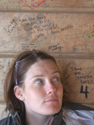
Taken from the Harding Icefield shelter. If you look closely you can see the writing on the wall that says, "I have very sensitive knees."
Granite Tors Trail, Chena River Recreation Area outside of Fairbanks

view from the beginning of the descent
This is one of the best hikes I've ever been on because of the diversity of plant life, the constantly changing landscape, the amazing vistas, and the physical challenge of it. The Granite Tors Trail is a fifteen mile loop. Just past the midway point, is "Monument Plain," a flat expanse of tundra with several granite outcroppings worthy of rock climbing. The trail begins on a boardwalk that follows the edge of the Chena River for several miles before zig zagging through a Birch and Aspen forest and ascending into Spruce. Because the Alaskan spring and summer are short and much later than they are in the Sierras, even a mid-July hike promises perfect wildflower viewing with lupines, columbines, and fireweed waving their purples and pinks in the wind. We set out on a blustery day, not even hitting the trail until 2:00 pm, unheard of in the Sierras. Because we'd been pelted by rain for the better part of a week, we made no promises to walking the whole fifteen miles that day, especially since. We ended up having our fair share of sprinkles and light showers, but it only allowed the sky to match the dramatic landscape and give shadow to cool our perspiration. After mile six, there was no turning back because it's so close to halfway that the end feels closer.

among the granite tors
It wasn't until after 10:00 p.m., as we were in the thick of our descent down a roughly talused slope, traversing a mountain without a sign of the trail ahead (just hoping we would run into it again), that I began to worry about bears. I can't say I'd ever been on a day hike at 10:00 p.m. At this point, I'd normally be bedded down for the night, watching the moon rise over the landscape (how I miss the moon now on day 34 above 60 degrees latitude). Only at this late hour, did I begin to think we'd been stupid to leave so late and so casually. My knees started to ache at the weight of downhill. I am cautious and too slow where Curt nearly flies downhill. I'd choose the uphill chug any day because I can get in a predictable rhythm where my heartbeat feels strong and I can almost find enough oxygen to sing too (a good way to keep bears away, we suspect). The Granite Tors Trail offered us everything an Alaskan hike promises. At 11:00 p.m., we arrived back at our campground starved for dinner. We didn't need to find the head lamps or lanterns, we could make our dinner by the cloud-covered twilight of the Alaskan summer night.
For more information on the Granite Tors Trail, check out: http://www.dnr.state.ak.us/parks/units/chena/trails.htm
Angel Rock Trail, Chena River Recreation Area, outside Fairbanks
Because the Granite Tors Trail had been such a big hike, we thought we'd take it easy with a simple ten mile hike, splitting it up by hiking five miles in to sleep and five miles out. Also in the Chena River Recreation Area, the Angel Rock Trail traverses similar landscape. Five miles into the trail is a shelter, perfect for a night. Since the weather called for more rain, we thought it a perfect respite from camping in the rain. Five miles in should have been nothing to think twice about. But, this is Alaska where five miles is so much more than five miles. The rain pelted us and instantly made us cold. We were soggy from the inside out within a half hour of our hike. As we proceeded, it felt like hordes of people passed us on their way out, rushing for their cars, and soon for the warmth of the nearby Chena Hot Springs. We kept on, but that shelter at the end of five miles was far away with one false peak after another until we finally saw the little hut at the bottom of the promised "third saddle" of the mountain. The shelter was stocked with an ax, two saws, lots of kindling and paper, a snow shovel, and a stove. Unfortunately, there wasn't any dry wood. Curt set out with the ax and delighted in hacking down the underbrush of dead trees, hoping they would be the least wet. We had a fast burning fire for several hours before we decided the warmest place to be was asleep.
The morning brought partial clouds and even a sliver of sunshine. As we hiked out an ominous black cloud seemed to be following us, but we managed to outwit it or outpace it. It wasn't until the edge of the rock outcropping about two miles from the trail head that my knee decided it was done. The last two miles to the car were excruciatingly slow. Sometimes I dragged my leg, like dead weight because it was less painful than bending it. Sometimes, I just pushed myself forward through the pain thinking if I went fast I wouldn't feel it as much. Other times, I just had to sit down and pretend I could teleport. Curt made me give him my pack despite my stubborn resistance. I imagine his hike down was painful too with two backpacks on him. When my knee miraculously hurt less, I took my pack back and pushed through. Angel Rock Trail, then, was a little tainted by the effort of backpacking with a bum leg, but on a normal day as a quick day hike, exploring the trail even partially is worth the time.
Angel Rock is also maintained by the Division of Parks and Outdoor Recreation. See the link above.
Harding Icefield Trail, Kenai National Park, Seward, Alaska

I came to Seward because it's the gateway to the Kenai National Park, a park with only one road (the one leading to Exit Glacier). To explore the park, you have to kayak Resurrection Bay and its many coves (Humpy, Thumb, Aailik, and Bear), have a water taxi drop you off at a trail head, or fly into the park and hope to be picked up when you are done. We opted for exploring the fjords mostly by kayak, but there was one trail I had my eye on for months -- the Harding Icefield Trail. All of the glaciers of the Kenai Fjords are fed by the massive Harding Icefield, the only icefield that is completely contained within the U.S.

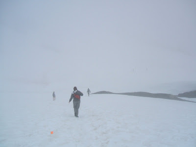
The Harding Icefield Trail is a 7.8 mile round trip. It's straight up to the peak and straight down to the end. The hike begins next to Exit Glacier and slowly climbs up a trail carefully crafted by the National Park Service. After two miles, the trail crawls through Marmot Meadows where marmots can be spotted as well as both black and brown bears. We spotted only one black bear, though others on the trail encountered a black bear mama and her cubs. Locals tell us that these bears were born on the mountain and have seen humans since their birth; they do not think of them as food or as a threat. Still, precautions are always wise. We stuck to belting out Johnny Cash tunes and shaking a can of mints as if a tambourine. Not long after Marmot Meadows, the trail becomes snow-packed. Some have called 2008 "the summer that never was." In other words, it's been cold and wet this summer, and it appears there was even fresh snow on the mountain. For the last two miles, the trail consists of long snowbound switchbacks. As the trail climbs, there's a view of Exit Glacier below and all of the deep blue crevasses. To my surprise, there are hoary marmots up there in the snow and even signs (scat) of bear that far up. I would have liked to have spotted a lynx, but they remain mysterious. At the false summit is a shelter, this one signed by everyone who has passed through. Another half mile takes the trail to the real summit, which upon our arrival was so clouded in that we could not see anything but a sheet of white. We knew there was an Icefield below, but it had no shape or definition to us.
 The descent was an adventure. Climbing down the mile of snow, it was much easier to use our feet as skis. Once I slipped and landed right on my butt and found it much easier to travel by sitting down. I scooted along on the trail a good fifty feet before standing up to plod ahead on both feet. The Harding Icefield was all it promised to be, but again much harder than the trail description or my expectations of it. There are few eight miles hikes I have been on that take eight hours to complete!
Harding Icefield Trail Information: http://www.nps.gov/kefj/planyourvisit/harding_icefield_trail.htm

Taken from the Harding Icefield shelter. If you look closely you can see the writing on the wall that says, "I have very sensitive knees."
Granite Tors Trail, Chena River Recreation Area outside of Fairbanks

view from the beginning of the descent
This is one of the best hikes I've ever been on because of the diversity of plant life, the constantly changing landscape, the amazing vistas, and the physical challenge of it. The Granite Tors Trail is a fifteen mile loop. Just past the midway point, is "Monument Plain," a flat expanse of tundra with several granite outcroppings worthy of rock climbing. The trail begins on a boardwalk that follows the edge of the Chena River for several miles before zig zagging through a Birch and Aspen forest and ascending into Spruce. Because the Alaskan spring and summer are short and much later than they are in the Sierras, even a mid-July hike promises perfect wildflower viewing with lupines, columbines, and fireweed waving their purples and pinks in the wind. We set out on a blustery day, not even hitting the trail until 2:00 pm, unheard of in the Sierras. Because we'd been pelted by rain for the better part of a week, we made no promises to walking the whole fifteen miles that day, especially since. We ended up having our fair share of sprinkles and light showers, but it only allowed the sky to match the dramatic landscape and give shadow to cool our perspiration. After mile six, there was no turning back because it's so close to halfway that the end feels closer.

among the granite tors
It wasn't until after 10:00 p.m., as we were in the thick of our descent down a roughly talused slope, traversing a mountain without a sign of the trail ahead (just hoping we would run into it again), that I began to worry about bears. I can't say I'd ever been on a day hike at 10:00 p.m. At this point, I'd normally be bedded down for the night, watching the moon rise over the landscape (how I miss the moon now on day 34 above 60 degrees latitude). Only at this late hour, did I begin to think we'd been stupid to leave so late and so casually. My knees started to ache at the weight of downhill. I am cautious and too slow where Curt nearly flies downhill. I'd choose the uphill chug any day because I can get in a predictable rhythm where my heartbeat feels strong and I can almost find enough oxygen to sing too (a good way to keep bears away, we suspect). The Granite Tors Trail offered us everything an Alaskan hike promises. At 11:00 p.m., we arrived back at our campground starved for dinner. We didn't need to find the head lamps or lanterns, we could make our dinner by the cloud-covered twilight of the Alaskan summer night.
For more information on the Granite Tors Trail, check out: http://www.dnr.state.ak.us/parks/units/chena/trails.htm
Angel Rock Trail, Chena River Recreation Area, outside Fairbanks
Because the Granite Tors Trail had been such a big hike, we thought we'd take it easy with a simple ten mile hike, splitting it up by hiking five miles in to sleep and five miles out. Also in the Chena River Recreation Area, the Angel Rock Trail traverses similar landscape. Five miles into the trail is a shelter, perfect for a night. Since the weather called for more rain, we thought it a perfect respite from camping in the rain. Five miles in should have been nothing to think twice about. But, this is Alaska where five miles is so much more than five miles. The rain pelted us and instantly made us cold. We were soggy from the inside out within a half hour of our hike. As we proceeded, it felt like hordes of people passed us on their way out, rushing for their cars, and soon for the warmth of the nearby Chena Hot Springs. We kept on, but that shelter at the end of five miles was far away with one false peak after another until we finally saw the little hut at the bottom of the promised "third saddle" of the mountain. The shelter was stocked with an ax, two saws, lots of kindling and paper, a snow shovel, and a stove. Unfortunately, there wasn't any dry wood. Curt set out with the ax and delighted in hacking down the underbrush of dead trees, hoping they would be the least wet. We had a fast burning fire for several hours before we decided the warmest place to be was asleep.
The morning brought partial clouds and even a sliver of sunshine. As we hiked out an ominous black cloud seemed to be following us, but we managed to outwit it or outpace it. It wasn't until the edge of the rock outcropping about two miles from the trail head that my knee decided it was done. The last two miles to the car were excruciatingly slow. Sometimes I dragged my leg, like dead weight because it was less painful than bending it. Sometimes, I just pushed myself forward through the pain thinking if I went fast I wouldn't feel it as much. Other times, I just had to sit down and pretend I could teleport. Curt made me give him my pack despite my stubborn resistance. I imagine his hike down was painful too with two backpacks on him. When my knee miraculously hurt less, I took my pack back and pushed through. Angel Rock Trail, then, was a little tainted by the effort of backpacking with a bum leg, but on a normal day as a quick day hike, exploring the trail even partially is worth the time.
Angel Rock is also maintained by the Division of Parks and Outdoor Recreation. See the link above.
Harding Icefield Trail, Kenai National Park, Seward, Alaska

I came to Seward because it's the gateway to the Kenai National Park, a park with only one road (the one leading to Exit Glacier). To explore the park, you have to kayak Resurrection Bay and its many coves (Humpy, Thumb, Aailik, and Bear), have a water taxi drop you off at a trail head, or fly into the park and hope to be picked up when you are done. We opted for exploring the fjords mostly by kayak, but there was one trail I had my eye on for months -- the Harding Icefield Trail. All of the glaciers of the Kenai Fjords are fed by the massive Harding Icefield, the only icefield that is completely contained within the U.S.

The Harding Icefield Trail is a 7.8 mile round trip. It's straight up to the peak and straight down to the end. The hike begins next to Exit Glacier and slowly climbs up a trail carefully crafted by the National Park Service. After two miles, the trail crawls through Marmot Meadows where marmots can be spotted as well as both black and brown bears. We spotted only one black bear, though others on the trail encountered a black bear mama and her cubs. Locals tell us that these bears were born on the mountain and have seen humans since their birth; they do not think of them as food or as a threat. Still, precautions are always wise. We stuck to belting out Johnny Cash tunes and shaking a can of mints as if a tambourine. Not long after Marmot Meadows, the trail becomes snow-packed. Some have called 2008 "the summer that never was." In other words, it's been cold and wet this summer, and it appears there was even fresh snow on the mountain. For the last two miles, the trail consists of long snowbound switchbacks. As the trail climbs, there's a view of Exit Glacier below and all of the deep blue crevasses. To my surprise, there are hoary marmots up there in the snow and even signs (scat) of bear that far up. I would have liked to have spotted a lynx, but they remain mysterious. At the false summit is a shelter, this one signed by everyone who has passed through. Another half mile takes the trail to the real summit, which upon our arrival was so clouded in that we could not see anything but a sheet of white. We knew there was an Icefield below, but it had no shape or definition to us.
 The descent was an adventure. Climbing down the mile of snow, it was much easier to use our feet as skis. Once I slipped and landed right on my butt and found it much easier to travel by sitting down. I scooted along on the trail a good fifty feet before standing up to plod ahead on both feet. The Harding Icefield was all it promised to be, but again much harder than the trail description or my expectations of it. There are few eight miles hikes I have been on that take eight hours to complete!
Harding Icefield Trail Information: http://www.nps.gov/kefj/planyourvisit/harding_icefield_trail.htm
Comments